


Following the recent launch of the YellowScan Navigator, we thought it would helpful to delve into how bathymetric LiDAR technology is leading the way for underwater exploration and mapping for Australian businesses.
We’re doing so in a 3 part Navigator Series. To kick that off, let's explore the unique capabilities and enhanced features that make the Navigator a game-changer for professionals in marine research, environmental monitoring, and coastal management.
Why green LiDAR?
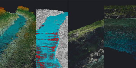
YellowScan’s choice of a green laser is deliberate, harnessing the most effective wavelength for water penetration. This ensures that the Navigator delivers optimal clarity and detail across various water conditions, making it an indispensable tool for accurate underwater mapping and analysis.
Enhanced features for comprehensive mapping:
- Increased precision: Achieve unparalleled accuracy with a precision of 3cm (1.2 inches), capturing every detail of the underwater terrain.
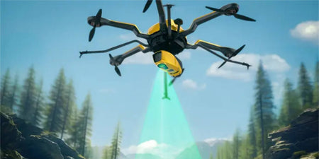
- Extended range and field of view: With a laser range up to 120m and a 44° field of view, the Navigator is designed to cover extensive areas efficiently.
- Capture at depth: Capture data from water bodies up to 2 Secchi deep, ensuring all data is captured.
- Integrated camera: Enhance your data collection with colourised imagery, adding depth and detail to your mapping projects.
The Navigator excels across a spectrum of applications, from riverbed analysis to submarine archaeology. Its compatibility with various UAV platforms, including Acecore’s Noa ensures flexibility for diverse mission requirements, empowering businesses to tackle any challenges with confidence.
The Navigator is more than a LiDAR system, it's a key to unlocking new potentials in underwater exploration. With ongoing support and comprehensive training, you’re equipped to navigate the complexities of bathymetric mapping with ease and precision.