


The Australian agriculture industry has many challenges. Unpredictable weather patterns, crop disease, irrigation issues and pest control to name a few. Adding additional pressure are traditional methods of evaluating and managing farm environments. Being labour and resource intensive, they are also time consuming, costly and often not successful.
Enter drone technology.
Let us preface this by saying that drone technology is not new technology. However, thanks to investment in their development across the globe and a ‘somewhat’ practical regulatory environment in Australia, it appears their time has truly arrived—particularly in the field of agriculture.
Known as unmanned aerial vehicles (UAVs) inside the industry —or for the person on the street – simply ‘drones,’ they have been used in commercial applications since the 1980s in the US and since the 1990s here in Australia.
Today, commercial applications for drones are rapidly expanding across a wide variety of industries. Responding to this evolving technology and industry use, a number of leading drone organisations in Australia are developing proprietary solutions and proof of concept models for drone-use. These include commercial applications including Australia’s wide and incredibly diverse agriculture industry.
For agriculture, the good news is that smart farmers in Australia are embracing drone use as well as revolutionary strategies for producing food, increasing productivity and making sustainability a priority. Drone technology in particular is giving the Australian agriculture industry a high-technology makeover, with planning and strategy based on real-time data gathering and processing.
Here are some examples of drone technology currently in use in Australian agriculture.
Crop monitoring: Vast paddocks and a low efficiency in traditional crop monitoring is certainly one of Australian farming’s largest obstacles. Monitoring challenges and unpredictable weather conditions create risk and paddock maintenance costs. Until drone use, satellite imagery offered the most advanced form of monitoring – but there were serious limitations. Images had to be ordered in advance, could only be taken once a day, were often not accurate and the process was extremely costly.
Today, drone-generated time-series animations are showing the precise development of crops and revealing production inefficiencies while enabling better crop management and outcomes at a fraction of the time and cost of traditional methods.
Soil and field analysis: Drones can be instrumental in the successful start of a crop cycle. With appropriate drone integrated sensors, precise 3D maps can be generated. These are extremely valuable for soil profile analysis essential for planning seed planting patterns. After planting, this soil analysis also provides data for irrigation and nitrogen-level management.
Crop spraying: By integrating distance-measuring equipment onto a drone – for example, ultrasonic echoing and lasers such as those used in light-detection and ranging, or LiDAR – they have the ability to rapidly adjust their altitude as the topography and geography vary. With this ability, drones can scan the ground and spray the correct amount of liquid at the right distance and in real time for even coverage.
The result is a massive increase in efficiency as well as a substantial reduction in the amount of chemicals penetrating groundwater. As important for cost efficiency, aerial spraying can be completed up to five times faster with drones than with traditional machinery.
Irrigation: Drones with hyperspectral, multispectral, or thermal sensors can identify those parts of a paddock that are dry or may need irrigation improvements. As well, once the crop is growing, drones allow for the calculation of the vegetation index, which (in simple terms) describes the density and health of the crop.
Health assessment: It’s essential to assess crop health and identify bacterial or fungal infections on crops and trees. Drones with appropriate sensors integrated, can scan crops using both visible and near-infrared light. These sensors can identify the health and vigour of plants and from this information, images can be produced that monitor changes in plants and indicate their growth characteristics. Indeed, once identified, a speedy response can save an entire paddock or orchard.
So what are the best drones and payloads for agricultural applications?
Fixed-wing UAVs are typically the best choice when you have to cover a lot of ground quickly and in Australia, this can be quite a lot! Fixed-wing drones can cover up to 10 times the hectarage that a typical quadcopter can cover in a single flight. This noted, quadcopters offer other advantages to an application.
So what do we recommend?
Fixed wing:
The Delair DT18 Ag has proven itself in agricultural solutions both in the US and here in Australia. It can capture 200 hectares worth of data on a single battery charge, is easy to fly, comes complete with Micasense Redge Edge 5-band spectrum sensor ( visible/RGB + red edge + near infrared), and has advanced flight planning, flight management and image processing software.
The DT18 Ag includes Delair’s proprietary Ag flight planning and ground station software, making the process of creating a flight plan with the Micasense sensor simple.
To get underway, the pilot only needs to establish the area to survey, set the image resolution and define the desired image overlap. Then, the software generates an optimal flight plan.
In a single Delair DT18 Agflight you can capture:
- Vegetation indices (NDVI, CCCI, NDRE, MCARI, CWSI)
- Plant counts
- Soil H20 levels
- Soil temperature
- Topography / 3D mapping (limited / not survey quality)
We highlight the UX11 a little in advance of its availability (January 2019) as we believe it will be an agricultural application game-changer!
The UX11 is a fixed wing drone enabling highly efficient flight characteristics for long flight times, which equates to excellent area mapping. An established and efficient drone, it is easy-to-fly and can generate soil profile maps, contours of the land and soil erosion maps.
The UX11 PPK version, enables the user to map 100 hectares in a single flight with a height accuracy of 25mm and using a minimum of survey ground control points.
Hand-launched, it has fully autonomous flights and a revolutionary ‘bird-like’ landing via its deep angle stall and flare out just above the ground. This allows it to land in very confined areas.
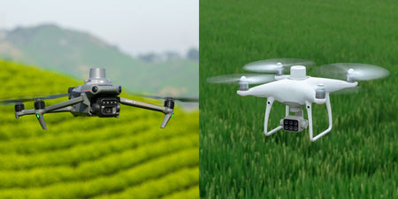
Quadcopter:
A multi-rotor drone is a better choice for close-in scouting, spotting and detailed surveying tasks than a fixed wing drone.
Flying a multi-rotor drone, low and slow, gives you far more control over every image you shoot. As a result, accuracy and resolution are often better than fixed wing UAVs can deliver.
The trade off, of course, is you have far less range and coverage per flight. Most multi- rotor agricultural drones can’t cover more than 50 hectares between charges / battery swaps.
This noted, the DJI drone range is exceptional across multiple commercial applications. For agriculture solutions, we recommend the DJI Phantom 4 Pro.
The DJI Phantom 4 Pro allows farmers to evaluate their crops at ‘scale’ while simultaneously creating crop maps that help them manage crops and time better. They are also portable, and boast industry leading flight times. Equipped with 20 megapixel cameras and up to 4K video they capture clear, detailed images that are essential for analysis and every Phantom is ready to fly out of the box.
As part of our own in-house development process, we have advanced the DJI Phantom’s agricultural payload capabilities with the integration of the MicaSense RedEdge-M Multispectral camera. This is one of the world’s leading cameras for agricultural, drone driven solutions.
With the ability to produce narrow and calibrated spectral bands and with near infrared capability, it has frequencies of light that work in with popular crop index products – Normalized Difference Vegetation Index (NDVI) and Normalized Difference Red Edge (NDRE).
This provides users an accurate measure of not just plant and crop vigour, health and growth, but also indicatives of soil water content and quality.
If you are new to drone technology, we highly recommend you speak to a UAV specialist that can advise you on both drone options and the best approach to your agricultural application.
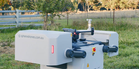
Sphere Drones is arguably Australia’s leading source of expertise on commercial drone technology and agricultural solutions in Australia.
Their Sydney-based operation is a state-of-the-art solutions development facility with some the UAV industry’s leading personnel – making it (or their website) a logical first stop to identify a solution for your commercial needs.