

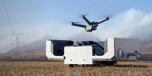


The more capable yet noticeably smaller DJI Dock 2 deploys Matrice 3D or 3TD drones with ease and security. Dock 2 is lightweight, offers high-level operation capabilities, and has cloud-based intelligent functions that bring efficiency and quality to automatic operations.
Easy Deployment, Ready to Go
Lightweight design
Compared to the first-generation dock, the volume and weight of DJI Dock 2 have been reduced by 75% and 68% respectively. It can be carried by two people, greatly improving flexibility and reducing installation costs.
Efficient site evaluation
Before deployment, the Matrice 3D series [4] can detect the surrounding environment through visual sensors and quickly determine whether the deployment area has good GNSS signals.
Compared with the original survey plan, the new visual survey plan significantly speeds up site selection, and the time required is shortened from approximately 5 hours to 12 minutes [5].
Rugged, Reliable, Recharged
IP55 dustproof and waterproof
The dock is built and tested to IP55 rating [1], making it dust-proof and waterproof for ehanced operational capabilities across various environements. It can operate for a long time even in harsh climates and environments.
Environmental monitoring system
Dock 2 integrates sensors such as rain gauges, anemometers, and thermometers, which can sense weather changes in real time.
Combined with online weather forecasts, FlightHub 2 can provide timely warnings or suspend scheduled flight missions, effectively reducing risk.
More stable landings
Thanks to the new generation of image recognition technology, the Matrice 3D series can more accurately identify the landing area of the Dock 2. Not only that, the dock adopts a new sloped design to further improve the success rate of landing.
Built-in battery backup
In the event of an unexpected power outage, the dock can operate independently for more than 5 hours with the help of the built-in battery [7], leaving more than enough time for the aircraft to return and land.
Six-month maintenance interval
Thanks to the IP55 rated design and high reliability of the dock, it only needs to be maintained once every 6 months [8], effectively controlling labour investment costs.
Exception notifications
When a mission failure or emergency occurs at the dock or aircraft, FlightHub 2 will send notifications via text and email [9], allowing operators to accurately troubleshoot the problem.
High-Performance Aircraft Models
The all-new DJI Matrice 3D series is specifically designed for DJI Dock 2. Matrice 3D is equipped with both a tele camera and a wide-angle camera with a mechanical shutter, meeting the needs for 1:500 high-precision mapping tasks. Matrice 3TD, outfitted with a wide-angle camera, a tele camera, and an infrared camera, can depict both visible light and thermal images, making it suitable for security and inspection operations.
DJI Matrice 3D
Wide angle camera
- 4/3 CMOS sensor
- 24mm equivalent focal length
- 20 million effective pixels
- Mechanical shutter
Telephoto camera
- 1/2-inch CMOS
- 162mm equivalent focal length
- 12 million effective pixels
DJI Matrice 3TD
Wide angle camera
- 1/1.32 inch CMOS sensor
- 24mm equivalent focal length
- 48 million effective pixels
Telephoto camera
- 1/2-inch CMOS
- 162mm equivalent focal length
- 12 million effective pixels
Thermal camera
- Standard resolution - 640x512 @ 30fps
- Super resolution - 1280x1024 @ 30fps
- 40mm equivalent focal length
- 28x digital zoom
Cloud-Based Operation, Maximum Control
Cloud mapping
After the aircraft completes its flight task, DJI FlightHub 2 generates high-precision 3D models based on the collected flight data, authentically restoring the operating environment. These models can be annotated, measured, and downloaded.
Flight route editor
Utilizing high-precision 3D models, operators can conduct visual flight route editing from a first-person perspective and preview simulated imaging results. This facilitates intuitive and efficient operations and enhances flight route planning and accuracy.
AI Spot-Check
Frame a specific area in the 3D model, and the aircraft will automatically compare the area to be captured with the framed area in subsequent automated operations. This actively adjusts the camera's angle to ensure accurate capture of the same area across multiple flights.
FlyTo Tasks
DJI FlightHub 2's FlyTo tasks utilise high-precision 3D models to automatically plan the optimal flight route. Before an urgent task, the operator only needs to click on the subject, and the aircraft will fly to the destination via an efficient and safe route.
Live flight controls
Based on DJI FlightHub 2 or a third-party cloud platform, even if DJI Dock 2 is deployed in a remote region, the operator can still control the flight and gimbal angle via keyboard and mouse.
Obstacle bypass
When performing automatic flight tasks, the aircraft utilises omnidirectional obstacle sensing and automatic obstacle bypass functions to enhance the success rate of flight tasks.
Specifications
View specifications
Dock - General
-
product name
- DJI Airport 2
-
Total Weight
- The weight of 34 kg (excluding aircraft)
may vary due to different batches of materials and other reasons. Please refer to the actual product.
-
Dimensions
- Hatch cover open: length 1228 mm, width 583 mm, height 412 mm
Hatch cover closed: length 570 mm, width 583 mm, height 465 mm
The above data does not include the height of the anemometer (145 mm), but also includes the height of the tripod (55 mm).
-
Input voltage
- 100V to 240V (AC), 50/60 Hz
-
input power
- Maximum 1000 watts
-
Working temperature
- -25°C to 45°C
When the ambient temperature is lower than -20°C, the airport is in standby mode and the aircraft cannot perform flight missions.
-
Protection level
- IP55
-
Number of drones that can be stored
- 1 set
-
Maximum allowable landing wind speed
- 8 m/s
-
Maximum operating altitude
- 4000 meters
-
RTK base station satellite receiving frequency
- Also receiving:
GPS: L1 C/A, L2
BeiDou2: B1l, B2l, B3l
BeiDou3: B1l, B3l
GLONASS: L1, L2
Galileo: E1, E5B
-
RTK base station positioning accuracy
- Horizontal: 1 cm + 1 ppm (RMS)
Vertical: 2 cm + 1 ppm (RMS)
Dock - Charging Performance
-
The output voltage
- 28 volts DC
-
Charging time
- This data was measured when the aircraft (when powered off) was charged from 20% to 90% in a 25°C environment for 32 minutes .
Dock - Image Transmission
-
Image transmission solution
- O3 Image Transmission Industry Edition
-
working frequency
- 2.4000 GHz to 2.4835 GHz
5.725 GHz to 5.850 GHz
-
antenna
- Built-in four antennas, two transmitters and four receivers, supporting intelligent switching
-
Transmit power (EIRP)
- 2.4 GHz: < 33 dBm (FCC); < 20 dBm (CE/SRRC/MIC)
5.8 GHz: < 33 dBm (FCC); < 14 dBm (CE); < 23 dBm (SRRC)
Dock - Air Conditioning System
-
Operating Voltage
- 28 volts DC
-
Air conditioner type
- TEC air conditioner
Dock - Backup Battery
-
battery capacity
- 12 Ah
-
The output voltage
- 12 volts
-
Battery Type
- Lead-acid batteries
-
Battery life
- More than 5 hours
measured in an environment of 25℃ and with the battery fully charged. After a power outage, the airport does not support aircraft charging, air conditioning, hatch heating, anemometer heating and other functions. Please troubleshoot the fault in time.
Dock - Internet Access
-
Ethernet access
- 10/100/1000Mbps adaptive Ethernet port
-
4G access
- Requires cooperation with the DJI enhanced image transmission module.
It is only available in mainland China.
Dock - Sensors
-
wind speed sensor
- support
-
rain sensor
- support
-
ambient temperature sensor
- support
-
water immersion sensor
- support
-
cabin temperature sensor
- support
-
cabin humidity sensor
- support
Dock - Hatch Surveillance Camera
-
resolution
- 1920 × 1080
-
Viewing range (FOV)
- 151°
-
fill light
- white light fill light
Dock - In-cabin surveillance cameras
-
resolution
- 1920 × 1080
-
Viewing range (FOV)
- 151°
-
fill light
- white light fill light
Dock - Lightning Protection
-
AC power interface
- 20 kA protection (rated value), meeting Type 2 of EN 61643-11 and Class II protection level of IEC 61643-1
-
Ethernet interface
- 10 kA protection (total current value), meeting the Category C protection level of EN/IEC 61643-21
Dock - Software Support
-
app
- DJI Pilot 2 (cooperated with DJI RC Pro Industry Edition for deployment and debugging of DJI airports)
-
cloud platform
- DJI Sikong 2 cloud platform (supported by default)
third-party cloud platform (accessed through DJI cloud API development)
Dock - Expansion Capabilities
-
open protocol
- DJI Cloud API
-
edge computing
- Support external switch for data communication
Aircraft - General
-
Bare metal weight
- 1410g
This value includes the weight of the battery, propellers and microSD card and does not include third-party payloads. The weight may vary due to different batches of materials and other reasons, please refer to the actual product.
-
maximum takeoff weight
- 1610 g
-
size
- 335 mm long, 398 mm wide, 153 mm high (excluding paddles)
-
Wheelbase
- Diagonal wheelbase: 463.2 mm
Left and right wheelbase: 359.9 mm
Front and rear wheelbase: 291.4 mm
-
maximum ascent speed
- 6 m/s (normal gear)
8 m/s (sport gear)
-
maximum descent speed
- 6 m/s (normal gear)
6 m/s (sport gear)
-
Maximum horizontal flight speed (no wind near sea level)
- Normal gear, obstacle avoidance turned on: forward flight 15 m/s, backward flight 12 m/s, side flight 10 m/s.
Sports gear: forward flight 21 m/s, backward flight 18 m/s, side flight 16 m/s.
-
Maximum wind speed
- Wind resistance during operation: 12 m/s
Wind resistance during takeoff and landing: 8 m/s
-
Maximum takeoff altitude
- 4000 meters
-
longest flight time
- 50 minutes
Battery life measured in a controlled test environment. The specific test conditions are: an altitude of 20 meters, a windless laboratory environment, flying forward at a constant speed of 46.8 km/h, switching to photo mode (no photo operation during the process), obstacle avoidance behavior set to off, and flying to 0% remaining. power. Under different external environments, usage methods, and firmware versions, the results may vary to varying degrees. Please refer to actual experience.
-
Maximum hover time
- This data was measured when the DJI Matrice 3D series drone hovered at an altitude of 20 meters for 40 minutes
in a windless environment with 0% battery remaining. Under different external environments, usage methods, and firmware versions, the results may vary to varying degrees. Please refer to actual experience.
-
Maximum working radius
- This data was measured at 10 kilometers
under the conditions of ambient temperature of about 25°C, safe power level of 25%, ambient wind speed of about 4 meters/second, round-trip speed of about 15 meters/second, and hovering operation for 10 minutes. Under different external environments, usage methods, and firmware versions, the results may vary to varying degrees. Please refer to actual experience.
-
Maximum cruising range
- 43 kilometers
In a windless environment, this data was measured when the DJI Matrice 3D series drone flew at a constant speed of 54 kilometers per hour at an altitude of 20 meters with 0% battery remaining. Under different external environments, usage methods, and firmware versions, the results may vary to varying degrees. Please refer to actual experience.
-
Maximum tilt angle
- 25° (normal gear)
25° (sport gear)
-
Maximum rotation angular speed
- 250°/sec
-
GNSS
- GPS + Galileo + BeiDou + GLONASS (GLONASS is only supported when the RTK module is turned on)
-
Hover accuracy (no wind or light wind conditions)
- Vertical:
±0.1 meters (when visual positioning works normally)
±0.5 meters (when GNSS works normally)
±0.1 meters (when RTK works normally)
Horizontal:
±0.3 meters (when visual positioning works normally)
±0.5 meters (when GNSS works normally) )
±0.1 meter (when RTK is working normally)
-
Working temperature
- -20℃ to 45℃
-
Protection level
- IP54
-
motor model
- 2607
-
Propeller model
- 1149 Folding non-quick release propellers
-
RTK module
- aircraft integration
-
night navigation light
- aircraft integration
Aircraft - wide angle camera
-
image sensor
- DJI Matrice 3D: 4/3 CMOS, 20 million effective pixels
DJI Matrice 3TD: 1/1.32-inch CMOS, 48 million effective pixels
-
lens
- DJI Matrice 3D
Viewing angle: 84°
Equivalent focal length: 24 mm
Aperture: f/2.8 to f/11
Focus point: 1 meter to infinity
DJI Matrice 3TD
Viewing angle: 82°
Equivalent focal length: 24 mm
Aperture: f/1.7
Focus point : 1 meter to infinity
-
Lens defogging
- DJI Matrice 3D: The wide-angle lens supports defogging
DJI Matrice 3TD: The wide-angle lens supports defogging
-
ISO range
- DJI Matrice 3D: 100 to 6400
DJI Matrice 3TD: 100 to 25600
-
Shutter speed
- DJI Matrice 3D
Electronic Shutter: 8 seconds to 1/8000 seconds
Mechanical Shutter: 8 seconds to 1/2000 seconds
DJI Matrice 3TD
Electronic Shutter: 8 seconds to 1/8000 seconds
-
Maximum photo size
- DJI Matrice 3D: 5280 × 3956
DJI Matrice 3TD: 8064 × 6048
-
Photo shooting modes and parameters
- DJI Matrice 3D
single shooting: 20 million pixels
Timed shooting: 20 million pixels, 0.7/1/2/3/5/7/10/15/20/30/60 seconds
Low-light smart shooting: 20 million pixels
panoramic shooting: 20 million pixels (original material), 100 million pixels (synthetic material)
DJI Matrice 3TD
single shooting: 12 million pixels, 48 million pixels
Timed shooting: 12 million pixels, 48 million pixels, 0.7/1/2/3/5/ 7/10/15/20/30/60 seconds*
Low-light smart photography: 12 million pixels
Panoramic photography: 12 million pixels (original material), 100 million pixels (synthetic material)
* Not supported when taking 48 million pixel photos at a scheduled time 0.7 and 1 second intervals.
-
Video encoding and resolution
- H.264
4K: 3840 × 2160@30fps
FHD: 1920 × 1080@30fps
-
Video bit rate
- DJI Matrice 3D
4K: 130Mbps
FHD: 70Mbps
DJI Matrice 3TD
4K: 85Mbps
FHD: 30Mbps
-
Support file system
- exFAT
-
Image Format
- JPEG
-
video format
- MP4 (MPEG-4 AVC/H.264)
Aircraft - telephoto camera
-
image sensor
- 1/2 inch CMOS, 12 million effective pixels
-
lens
- Viewing angle: 15°
Equivalent focal length: 162 mm
Aperture: f/4.4
Focus point: 3 meters to infinity
-
Lens defogging
- DJI Matrice 3D: The telephoto lens supports defogging
DJI Matrice 3TD: The telephoto lens supports defogging
-
ISO range
- DJI Matrice 3D: 100 to 6400
DJI Matrice 3TD: 100 to 25600
-
Shutter speed
- Electronic shutter: 8 seconds to 1/8000 seconds
-
Maximum photo size
- 4000 × 3000
-
Image Format
- JPEG
-
video format
- MP4 (MPEG-4 AVC/H.264)
-
Photo shooting modes and parameters
- DJI Matrice 3D
single shooting: 12 million pixels
Timed shooting: 12 million pixels, 0.7/1/2/3/5/7/10/15/20/30/60 seconds
Low-light smart shooting: 12 million pixels
DJI Matrice 3TD
Single shooting: 12 million pixels
Timed shooting: 12 million pixels, 0.7/1/2/3/5/7/10/15/20/30/60 seconds
Low-light smart shooting: 12 million pixels
-
Video encoding and resolution
- H.264
4K: 3840 × 2160@30fps
FHD: 1920 × 1080@30fps
-
Video bit rate
- DJI Matrice 3D
4K: 130Mbps
FHD: 70Mbps
DJI Matrice 3TD
4K: 85Mbps
FHD: 30Mbps
-
digital zoom
- 8x (hybrid zoom 56x)
Aircraft - Infrared Camera (DJI Matrice 3TD)
-
Thermal imaging sensor type
- Unrefrigerated Vanadium Oxide (VOx)
-
Pixel spacing
- 12 μm
-
Frame rate
- 30 Hz
-
lens
- Viewing angle: 61°
Equivalent focal length: 40 mm
Aperture: f/1.0
Focus distance: 5 meters to infinity
Do not aim the infrared camera lens at strong energy sources, such as the sun, lava, laser beams, etc., otherwise the camera sensor may be burned , causing irreparable damage to it.
-
Sensitivity
- ≤50mk@F1.0
-
Temperature measurement method
- Point temperature measurement, area temperature measurement
-
Temperature measurement range
- -20℃ to 150℃ (high gain mode)
0℃ to 500℃ (low gain mode)
-
Palette
- white hot/black hot/red/iron red/hot iron/arctic/medical/lava/rainbow 1/rainbow 2
-
Image Format
- JPEG (8-bit)
R-JPEG (16-bit)
-
Video resolution
- Normal mode: 640 × 512@30fps
Super-resolution mode: 1280 × 1024@30fps (After turning on the infrared super-resolution function, the aircraft can automatically turn on or off the super-resolution mode according to the ambient light brightness.)
-
Video bit rate
- 6Mbps
-
video format
- MP4 (MPEG-4 AVC/H.264)
-
Photo shooting modes and parameters
- Single shooting
normal mode: 640 × 512
super-resolution mode: 1280 × 1024
timed shooting
normal mode: 640 × 512, 0.7/1/2/3/5/7/10/15/20/30/60 seconds
super-resolution mode : 1280 × 1024, 0.7/1/2/3/5/7/10/15/20/30/60 seconds
-
digital zoom
- 28 times
-
Infrared wavelength
- 8 μm to 14 μm
-
Infrared temperature measurement accuracy
- ±2℃ or ±2%, whichever is greater
Aircraft - gimbal
-
stable system
- 3-axis mechanical gimbal (pitch, roll, pan)
-
Structural design scope
- Pitch: -135° to +45°
Roll: -45° to +45°
Pan: -27° to +27°
-
Controllable rotation range
- Pitch: -90° to +35°
Pan: Uncontrollable
-
Maximum control speed (pitch)
- 100°/second
-
Angle jitter
- ±0.005°
Aircraft - Perception
-
Sensing system type
- There is a 10° visual blind zone at the rear and upper part of the six-directional obstacle avoidance aircraft
, so please fly with caution.
-
forward view
- Ranging range: 0.5 meters to 21 meters
Detectable range: 0.5 meters to 200 meters
Effective obstacle avoidance speed: Flight speed ≤ 15 meters/second
Viewing angle (FOV): 90° horizontally, 90° vertically
-
rearview
- Ranging range: 0.5 meters to 23 meters
Effective obstacle avoidance speed: Flight speed ≤ 12 meters/second
Viewing angle (FOV): 90° horizontally, 90° vertically
-
side view
- Ranging range: 0.5 meters to 15 meters
Effective obstacle avoidance speed: Flight speed ≤ 10 meters/second
Viewing angle (FOV): horizontal 104°, vertical 90°
-
looking up
- Ranging range: 0.5 meters to 21 meters
Effective obstacle avoidance speed: Flight speed ≤ 6 meters/second
Viewing angle (FOV): 90° front and rear, 90° left and right
-
looking down
- Ranging range: 0.5 meters to 14 meters
Effective obstacle avoidance speed: Flight speed ≤ 6 meters/second
Viewing angle (FOV): 95° front and rear, 110° left and right
-
Effective use of the environment
- Front, back, left, right, and top: The surface has rich texture and sufficient lighting conditions (>15 lux, normal indoor fluorescent lighting environment).
Bottom: The surface is made of diffuse reflection material with reflectivity > 20% (such as walls, trees, people, etc.), and the lighting conditions are sufficient (> 15 lux, normal indoor fluorescent lighting environment).
Aircraft - Image transmission
-
Image transmission solution
- DJI O3 Image Transmission Industry Edition
-
Real-time image transmission quality
- 720p/30fps, 1080p/30fps (with DJI RC Pro Industry Edition)
540p/30fps, 720p/30fps, 1080p/30fps (with Sikong 2 Cloud Platform)
-
Working frequency
- 2.4000 GHz to 2.4835 GHz
5.150 GHz to 5.250 GHz (CE: 5.170 GHz to 5.250 GHz)
5.725 GHz to 5.850 GHz
Some areas do not support the 5.1 GHz and 5.8 GHz frequency bands, and some areas only support the 5.1 GHz frequency band indoors. Please refer to local laws for details. regulations.
-
Maximum signal effective distance (no interference, no obstruction)
- DJI Matrice 3D
FCC: 15 km
CE: 8 km
SRRC: 8 km
MIC: 8 km
DJI Matrice 3TD
FCC: 15 km
CE: 8 km
SRRC: 8 km
MIC: 8 km
The above data are measured outdoors in an open and interference-free environment. It is the longest communication distance for a one-way non-return flight under each standard. Please pay attention to the return prompt on the Sikong 2 cloud platform during actual flight.
-
Maximum signal effective distance (with interference, without obstruction)
- Strong interference (dense buildings, residential areas, etc.): 1.5 kilometers to 3 kilometers (FCC/CE/SRRC/MIC)
Medium interference (suburban counties, city parks, etc.): 3 kilometers to 9 kilometers (FCC), 3 kilometers to 6 kilometers (CE/SRRC/MIC)
Weak interference (suburban areas, open farmland, etc.): 9 kilometers to 15 kilometers (FCC), 6 kilometers to 8 kilometers (CE/SRRC/MIC) The
above data is for aircraft (no third-party loads are installed) The flight was measured in various typical interference intensity and unobstructed environments. It is the longest communication distance for one-way non-return flight under various standards. Please pay attention to the return prompt on the Sikong 2 cloud platform during actual flight.
-
Maximum download rate
- 5MB/s (with airport)
15MB/s (with DJI RC Pro Industry Edition)
The above data were measured in a low-interference laboratory environment in countries or regions that support 2.4 GHz/5.8 GHz dual-band. Please refer to actual experience for the download rate. allow.
-
delay
- The image transmission delay from the aircraft to the airport is about 110 milliseconds to 150 milliseconds (affected by the actual environment).
The image transmission delay from the airport to the Sikong 2 cloud platform is affected by the actual network conditions and computer configuration.
-
antenna
- Four antennas, two transmitters and four receivers
-
Transmit power (EIRP)
- 2.4 GHz: < 33 dBm (FCC), < 20 dBm (CE/SRRC/MIC)
5.1 GHz: < 23 dBm (CE)
5.8 GHz: < 33 dBm (FCC/SRRC), < 14 dBm (CE)
-
other
- Support for using the DJI enhanced image transmission module
is only supported in mainland China.
Aircraft - Storage
-
Supported memory card types
- Aircraft:
Supports U3/Class10/V30 and above memory cards. It is recommended to use designated memory cards.
-
Recommended memory card list
- Aircraft:
SanDisk Extreme 32GB V30 A1 microSDHC
SanDisk Extreme PRO 32GB V30 A1 microSDHC
SanDisk Extreme 512GB V30 A2 microSDXC
Lexar 1066x 64GB V30 A2 microSDXC
Kingston Canvas Go! Plus 64GB V30 A2 microSDXC Kingston Canvas
React Plus 64GB V90 A1 microSDXC
Kingston Canvas Go! Plus 128GB V30 A2 microSDXC
Kingston Canvas React Plus 128GB V90 A1 microSDXC
Kingston Canvas React Plus 256GB V90 A2 microSDXC
Samsung PRO Plus 256GB V30 A2 microSDXC
Aircraft-Battery
-
capacity
- 7811 mAh
-
Voltage
- 14.76 volts
-
Charging limit voltage
- 17.0 volts
-
Battery Type
- Li-ion 4S
-
chemical system
- Lithium nickel cobalt manganate
-
energy
- 115.2 Watt hours
-
weight
- 544 grams
-
Cycles
- 400 times
-
Charging temperature range
- 5℃ to 45℃
Aircraft - Power Adapter
-
enter
- 100 V to 240 V (AC), 50/60 Hz, 2.5 A
-
Output Power
- 100 watts
-
output
- The maximum output power is 100 watts (total)
. When used simultaneously, the power adapter will dynamically allocate the output power of the two interfaces according to the load power. The maximum output power of one interface is 82 watts.
Aircraft - charging base
-
enter
- USB-C: 5V to 20V, 5.0A
-
output
- Battery connector: 12V to 17V, 8.0A
-
rated power
- 100 watts
-
charging method
- Single battery charging
-
Charging ambient temperature
- 5℃ to 40℃
Talk to us about DJI Dock 2
For inquiries or more information, please fill out the form below, and our team will contact you as soon as we can.
- * Always check and strictly abide by local laws and regulations before flying.
- ** All data on this page was collected using a production model DJI Dock 2 and DJI Matrice 3D/3TD in a controlled environment. Actual results may vary depending on the environment, usage, and firmware version.
- *** All videos and images on this page were shot in strict compliance with relevant local laws and regulations.
- **** DJI Matrice 3D/3TD must be activated via the DJI Pilot 2 app before use.
- ***** To ensure that the equipment operates steadily and continuously, please perform regular maintenance. For details, refer to the Maintenance Manual.
- DJI Dock 2 is IP55 rated, and DJI Matrice 3D/3TD is IP54 rated. Both are tested under controlled laboratory conditions. The IP rating is not permanently effective and may decrease due to product wear and tear. For details, refer to the User Manual.
- Measured in an environment of approximately 25°C (77°F) with a reserve battery level of 25%, ambient wind speed of approximately 4 m/s, round-trip flight speed of approximately 15 m/s, and hovering operation of 10 minutes. This value is for reference only, and the actual operation data may vary.
- Sold separately.
- DJI Matrice 3D/3TD or the DJI Mavic 3 Enterprise Series aircraft can be used.
- When the aircraft has sufficient battery level, the following operations can be completed in 12 minutes: Turn on the DJI Matrice 3D Series drone and connect it to the DJI RC Pro Enterprise. Enter DJI Pilot 2, select the Dock Site Evaluation function, and then finish the site evaluation step by step according to the instructions until the evaluation results are obtained. This value is for reference only, and the actual experience may vary.
- Measured with a fully charged backup battery in a 25°C (77°F) environment. After a power outage, the dock does not support functions like aircraft charging, air conditioning, dock cover heating, and wind speed gauge heating. Always check malfunctions promptly.
- Measured in a windless, sand-free, and non-erosive environment at 25°C (77°F). Actual maintenance intervals should be determined based on the deployment environment and operating frequency. It is recommended to conduct maintenance every six months or sooner.
- Measured in a controlled test environment. Specific test conditions are as follows: flying forward at a constant speed of 46.8 kph in a windless laboratory environment at 20 meters above sea level, in photo mode (without photo-taking operation during flight), with Obstacle Avoidance Action set to Off, and from 100% battery level until 0%. Results may vary depending on the environment, actual use, and firmware version.
- The aircraft has a 10° blind spot in the upper rear area. Always fly with caution.
- Within 12 months, when the ambient temperature for battery storage is below 35°C (95°F), and the cumulative time with a battery level of 90% or higher is less than 120 days, the battery cycles can reach 400 times.
- In an environment with good network signals, it takes approximately 45 seconds, the fastest from when the operator clicks Take Off in DJI FlightHub 2 to when the aircraft leaves the landing pad. This value is for reference only, and the actual experience may vary.
- Measured in a 25°C (77°F) environment while charging. 13.Please consult your dealer first to ensure that the payload is compatible with DJI FlightHub 2.